The Impressive Conquer of the Jigsaw Method & Teaching Geography
Throughout these past two weeks, we were introduced to the Jigsaw Method and engaged into two experiences that revolved around the Jigsaw Method. The Jigsaw Method is a cooperative learning method that requires there to be "base" group and "expert" groups. The first topic that was approached was the concepts of cooperative learning. Each of the expert groups were responsible for teaching the class an aspect of the 5 elements of Cooperative Learning while my expert group focused primarily on the similarities and differences between a Direct Instruction and a Cooperative Learning instruction. By participating in this type of activity, I first handily developed the feeling of what it would be like for a student following the Jigsaw Method and by cross examining the characteristics of a Direct Instruction and a Cooperative Learning lesson, I was able to clearly see how both techniques are related and how they differ. It was interesting to take a close look at the true differences between the two lesson techniques. I feel that both instructions are needed in the classroom, but I do feel that perhaps a combination of the two ways of teaching should be a positive part of a classroom routine.
Click here to view the Google Slides presentation that I created for this experience.
Click here to view the Google Slides presentation that I created for this experience.
Direct Instruction vs Cooperative Learning
 |
| This is a Venn Diagram as the Exit Ticket for a collaborative effort of demonstrating the similarities and differences between a teacher-centered direct instruction and a student-centered cooperative learning lesson. |
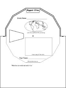
Using the Jigsaw Method while Teaching Geography
 Click here to view the collaborative experience through Google Slides.
 As an Informational Technology Major that focuses in Education, I always like to add a technology twist to learning and I am infatuated by the features of Google Earth. Google Earth provides a virtual reality simulation of the countries around the world. Referring to video above, I was captivated by the ideas provided by Google Expeditions which uses a "Google Cardboard" as the virtual simulation goggles that will give the students a virtual field trip to places all around the world, while remaining in their classroom. I completely believe that this type of experience will leave a meaningful impact on students when teaching geography because it visually provides the students with an experience that will be hard to forget.
Another method that I would personally make use of in my future classroom would to "produce a wheel." By creating a concept wheel, the students can do a lot of research, but present the information in a creative, engaging way that does not primarily revolve around writing words. When I was in Elementary School, I did not like to write big paragraphs or long essays, so I would always find myself drawing pictures. In a concept wheel, the students do not only have to use words, but they can draw symbols and pictures. I enjoyed learning about all types of methods that I can use in the classroom to teach geography and I will use some of these methods in my future practice, without a doubt.
The task for completing this strategy was to select an Indian American tribe that we could be "experts" in discussing and be ready to share our findings with our "base" group. Before actually starting, we decided which tribes each of us would do back within our base groups. Than we separated into expert groups and collaborated to create a wonderfully laid out presentation of the Mohawk/Iroquois tribe. I enjoyed this topic because I was able to relate it back to when I was in Elementary School and we were talking specifically about the Iroquoians and their life styles. After we completed the task, we reunited with our base groups and each of us had a chance to share and present our informational facts about the selected tribes to teach each other. I felt that this approach was a simple approach to teaching Geography, but I do see some flaws that could come up when teaching this type of way in the classroom. Some students may gain more knowledge than others and share different experiences which could leave some children behind with knowing the desired knowledge to achieve the objective of the lesson.
When I used to think about teaching Geography, I used to immediately think about using the globe and right away driving my attention to grabbing a book about a specific country and focusing my lesson primarily around the information that I read in the book. Now, I have learned that there is a lot more to teaching Geography that I could have imagined and I have developed a "new found love" for teaching Geography. Yes, it's nice to use a globe and have a reading to support the information, but Geography can be taught more in depth with real-world experiences and through features that teachers who are inexperienced with technology could even think about.
 |
| Beach on Paper Plate |
 |
| Lake/Pond on a Paper Plate |
Another method that I would manipulate in my classroom would be making a landscape box or making a place on a paper plate. Each student would have their own country and be able to make their own intake on the country or scenic area in a small box or on a paper plate. It is similar to a diorama. I like this approach because I am a kinesthetic learner that enjoys doing arts and crafts in almost everything that I do. After making a landscape box or paper plate place, I could even have a time during the day which could be called "Travel around the world" or "The world's museum" and the students could walk around to view all of the different views and opinions of the other students on the scenes and landscapes. This could even become a collaborative assignment in which the students will be working together to achieve a common goal and cooperatively create a master piece.
 |
| Landscape Box |
Another method that I would personally make use of in my future classroom would to "produce a wheel." By creating a concept wheel, the students can do a lot of research, but present the information in a creative, engaging way that does not primarily revolve around writing words. When I was in Elementary School, I did not like to write big paragraphs or long essays, so I would always find myself drawing pictures. In a concept wheel, the students do not only have to use words, but they can draw symbols and pictures. I enjoyed learning about all types of methods that I can use in the classroom to teach geography and I will use some of these methods in my future practice, without a doubt.
No comments:
Post a Comment